California – Loop Trail in Torrey Pines State Reserve near San Diego

There is nature to discover on the this loop trail in Torrey Pines Nature Reserve, a rugged segment of land on the California coast near San Diego. Surrounded by urban life, the nature reserve is a lovely area to explore the natural landscape, including high cliffs and deep ravines. The reserve also boasts a mix of flora, including its namesake, the Torrey Pine. I did a 1.6-mile looping hike to explore the reserve that combines Red Butte, Razor Point, and Yucca Point. I loved the loop to explore/see the different zones while also not having to double back on the trail.
The trails are well-marked and wide enough for people to pass each other. We did Red Butte first, then Razor Point, and finally Yucca Point. There is uneven footing (especially at Red Butte) and elevation change. As you head to the points, you will lose elevation, so bring plenty of water and snacks to get yourself back up the hill.
This post contains affiliate links, which means if you make a purchase through these links, I may receive a small commission at no extra cost to you. The commissions help support Moderately Adventurous stay alive and kicking. Click here to read my full disclosure policy.
Loop Trail in Torrey Pines: Red Butte – Razor Point – Yucca Point trail
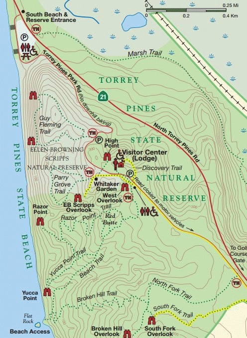
Coming into Torrey Pines State Reserve, we went right by the beach and drove up the road that circles the backside of a large hill. The road is curvy with cyclists and pedestrians, so go slow and keep an eye out. We passed by other trailheads and ended up driving to essentially the end of the road and parked in the lot on the ocean-side. There are signs with information and temporary bathrooms available (I’m not sure why the bathrooms were closed when we visited).
After applying sunscreen, we started on the trail toward Red Butte and then planned to make a loop to Razor Point and Yucca Point. The trail begins at the highest elevation and slowly descends toward the points. The path is wide and sandy, making it easy to pass by other people.
Red Butte
I recommend checking out Red Butte first! There are a couple of different routes to get to Red Butte but don’t stress, they are relatively short, and the significant intersections had a map posted in black and white, which is just like this one. Once you get to the Butte itself, you can climb on top and see a 360-degree view of Torrey Pines State Reserve, including where to go next. Be careful walking around because the butte is an uneven, wavy, pothole-esque texture that is difficult to walk across.
Some of my favorite photos were at the top of Red Butte. Take your time up here if it’s busy. There is often a natural lull in the crowd, where you can get an uninterrupted view in a particular direction.
At a Glance:
- Rating: 3 (out of 4) stars, would go again
- Intensity: Hiking (or tennis shoes), athletic clothes
- Location: Torrey Pines State Natural Reserve
- Cost: $10 – $25 per vehicle, based on demand (this is a little confusing to me, but when we visited, it was $10 or $11 – I cannot remember!)
- Restrooms: There were some temporary restrooms available when
- Timing: 2 – 3 hours
- Distance: 1.6 miles
- Elevation Gain: 216 ft
Highlights:
- Great loop trail with ocean views to experience the Torrey Pines of San Diego
- Three different goal points to check out: Red Butte, Razor Point, and Yucca Point.
- Option to add on the Beach Trail and see this segment of protected beaches or the West Overlook at the trailhead.
- Fun contrast of pine trees and cactus plants!
Lowlights:
- This hike can get popular
- Mostly unshaded trail, which means few Torrey Pine trees. They are still around, but maybe not as many on this trail as the other trails.


Razor Point
The loop part of the trail starts at Red Butte. We headed down the path on our right when facing the ocean that would lead to Razor’s Point and made the loop in a counter-clockwise direction. It was on the switchbacks that it noticed that the landscapes seemed parched. One part of this could be visiting in September after an arid year. And the other part of it is the natural floral, which includes a mix of cacti. So interesting to have a mix of cactus and pine trees in one place!
Razor Point is a lovely overlook on a triangular razor-shaped cliff, and you can see the erosion of the cliffs that make the hill formations look like badlands. We didn’t spend much time here as it was bustling, so we opted to head over to Yucca Point quickly.
The trail between Razor Point and Yucca point was probably my favorite section (not including the major sights). It was tranquil and followed the cliff in between the two peninsula-type points. The views included more vegetation, which was an interesting comparison to the ocean beyond. Before we knew it, we were at the turn-off to Yucca Point.
Yucca Point + The Return Trip
Based on a couple of maps I’ve seen and the paths I saw in person, Yucca point used to have a tiny loop at the tip. But to preserve the natural spaces, it is now a single in-and-out path with a wooden fence on either side. The point itself has a stunning view of the ocean and looks south toward San Diego. We had Yucca Point to ourselves for a full 5 to 10 minutes, so we soaked in the view and took some photos.
After we felt satisfied with our photos, we began the climb back up to the trailhead. On the path back, there is the option to connect to the beach trail and head down to the beach. If I had more energy and beach gear, this would be a lovely addition to the hike. After this turnoff, it’s time to climb. The climb is gradual and includes switchbacks, so it isn’t particularly hard. However, there is zero shade, so you’ll be sweating and out of breath depending on the temperature.
Near the top, you’ll come back across the Red Butte turn-off. Now you have completed the loop, and you can retrace your step on the last section of the trail back to the trailhead!


West Overlook
Once I finished the entire loop, I made the short walk over to the West Overlook. It was nice to look out over Red Butte and the ocean in the shade of the Torrey Pines to understand the area better. The view is not as good as at Razor Point or Yucca Point, but still a lovely pit stop. It’s also an excellent place to cool off if you get heated on the climb back to the trailhead (I sure did).
Loop Trail in Torrey Pines – What to bring with you
Even though the Red Butte – Razor Point – Yucca Point Trail is not particularly long, I recommend bringing a small backpack with essentials, such as:
- Keep this map on your phone to reference or download the AllTrails Map.
- Day Pack – I used a small 16L backpack from Amazon. Consider the Gregory May 16 or small Osprey pack.
- Water bottle – You cannot go wrong with a handy dandy Nalgene
- Sunscreen – I use this sunscreen for my face, and this one for my body
- Small tripod for photos
- Snacks for the trail
Getting to the Trailhead
Once you are inside Torrey Pines State Reserve, head up the hill. The best trailhead for the Red Butte – Razor Point – Yucca Point Loop is at the top of the hill, across the street from the visitor’s center/lodge. There is a large parking area with bathrooms available. You can use Google Maps to route to this particular trailhead or the Torrey Pines State Reserve entrance.


Torrey Pines Galore
I didn’t expect to go to the only two places on earth with the Torrey Pine trees, but alas, these last few years have been wild. Aside from Torrey Pines State Nature Reserve, the only other location Torrey Pines grows is on Santa Rosa Island in Channel Islands National Park. Check out my blog post about my day trip to Santa Rosa Island and hiking through the trees.
The environments do seem very similar in a wind-swept coastal way. It could be the time of year I went, but it seemed like the Torrey Pines in San Diego were in a more desert-like setting with cactus plants not far away. In contrast, the Torrey Pines in Santa Rosa had a more tropical, lush, and dry environment.
Other Things to do in San Diego
I visited San Diego in mid-September as an alternative to Lake Tahoe with my family. Although it wasn’t our first pick, I had a blast exploring the city. Here are a couple more things we did while down south:
- San Diego Zoo, of course! My family went and had a delightful time, albeit pricey.
- Have a beach bonfire.
- Have the most incredible Vegan Ramen I’ve ever tasted at Yasai.
- Coffee Latte Flight at Communal Coffee then put that energy to explore Balboa Park.
- Watch the sunset from the sunset cliffs.
- Stop by the UCSD campus for a Plant Power breakfast burrito.
Overall Thoughts: Loop Trail in Torrey Pines State Reserve
The Red Butte – Razor Point – Yucca Point Loop trail is a great little nature hike while not being far from San Diego! It was wonderful to have three different points to check out, with the option to add on the beach or overlook. I will say that this trail does not have much shade, so come prepared for the sun! But that also means that there are not as many actual Torrey Pines on this trail. If you’re looking for a hike that goes through more Torry Pines, head to the Guy Fleming Trail or Parry Grove trail…. OR head four hours north to Channel National Park so that you can make the Torrey Pines Trail Loop on Santa Rosa Island.
What other hikes are in the San Diego area?? There is such an outdoorsy focus, but I wasn’t sure what hikes to do. Let me know in the comments, and I will be sure to check them out in the future!
Happy Travels,
Hanna


